
YELLOWMAPS
YellowMaps Magazine Mountain AR topo map, 1:125000 Scale, 30 X 30 Minute, Historical, 1890, Updated 1949, 20.7 x 17.1 in - Tyvek
1,235,53 kr.
2,059,21 kr.
Save 40% (823,68 kr.)
-
 Order within 1 hour and 57 minutes to get between May 13 - May 19
 -
 Tracked Shipping on All Orders
-
 14-Day Returns
- Secure Payments
-
 24/7 Customer Support
Description
- Printed on Tyvek® (synthetic)
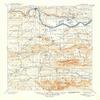
- USGS topographic map of Magazine Mountain, AR, at 1:125000 scale. Lighter material. Waterproof. Tear-resistant. Foldable. Very durable. Perfect for backpacking and the outdoors.
- Cities, towns, villages: Pleasant Hill,Tate,New Spadra,Girard (historical),Meg,Effa (historical),South Ozark,Sand Ridge,Peter Pender,Quarry Heights,Greenwood,Spielerville (historical),Hartman,Ozark,Blue Mountain,Dentontown (historical),Mountain Grove,Ratcliff,Dahoma (historical),Corley,Wiederkehr Village,Bushtown (historical),Sulphur Springs,Etna,Shady Grove,Driggs,Cotton Town,Ellsworth (historical),Union City,Chismville,Wilkins,Prairie View,Hoyt,Plainview,Midway,Grayson
- Mountains: Hole in the Ground Mountain,Short Mountain,Huckleberry Mountain,Pine Ridge Mountain,Horseshoe Mountain,Pine Hill,Potato Hill Mountain,Pine Mountain,Rich Mountain,East Snake Knob,Petit Jean Mountain
- Valleys: Whiteoak Valley,Pine Hollow,Saint Louis Valley,Long Hollow,Sorghum Hollow,Ferguson Valley,Ross Hollow,Greasy Valley,Bear Hollow,Ben Cove,Fox Valley
USGS topographic map of Magazine Mountain, Arkansas, dated 1890, updated 1949.
Includes geographic coordinates (latitude and longitude), lines of elevation, bodies of water, roads, and more. This topo quad is suitable for recreational, outdoor uses, office applications, or wall map framing.
Printed on-demand by YellowMaps on the print material of your choice.
Shipping rolled from Minneapolis, MN, United States.
Product Number: USGS-5429976
Map Size: 20.7 inches high x 17.1 inches wide
Map Scale: 1:125000
Map Type: POD USGS Topographic Map
Map Series: HTMC
Map Version: Historical
Cell ID: 65966
Scan ID: 260515
Imprint Year: 1949
Survey Year: 1887
Datum: Unstated
Map Projection: Polyconic
Map published by United States Geological Survey
Map Language: English
Scanner Resolution: 600 dpi
Map Cell Name: Magazine Mountain
Grid size: 30 X 30 Minute
Date on map: 1890
Geographical region: Arkansas, United States
Northern map edge Latitude: 35.5
Southern map edge Latitude: 35
Western map edge Longitude: -94
Eastern map edge Longitude: -93.5
Surrounding map sheets (copy & paste the Product No. in the search bar):
North: USGS-5682703,USGS-5429724,USGS-5429802,USGS-5429720,USGS-5425830
East: USGS-5429886,USGS-5429880,USGS-5429890,USGS-5429888,USGS-5429878
South: USGS-5429524,USGS-5430040,USGS-5430124,USGS-5430004,USGS-5430038
West: USGS-5429112,USGS-5430102,USGS-5429926,USGS-5429916,USGS-5426866
Shipping and Returns
- We offer tracked shipping on all orders. Tracking information will be shared as soon as the order is dispatched.
- Please check the delivery estimate before adding a product to the cart. This is displayed for every product on the website.
- Available shipping methods and charges will be displayed at the time of checkout, depending on your exact location.
- All customers are entitled to a return window of 14 days, starting from the date of delivery of the product(s).
- Customers are advised to read our return policy for details of the return process, eligibility, refunds as well as cancellations or exchanges.
- In case of any issues or concerns about Shipping or Returns, please contact us and we will be happy to help.
YellowMaps.
YellowMaps Magazine Mountain AR topo map, 1:125000 Scale,...
1,235,53 kr.
2,059,21 kr.
Save 40.0% (823,68 kr.)