
YELLOWMAPS
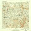
YellowMaps Llano TX topo map, 1:125000 Scale, 30 X 30 Minute, Historical, 1909, Updated 1958, 20.7 x 17.9 in - Polypropylene
1,114,93 kr.
1,858,22 kr.
Save 40% (743,29 kr.)
-
 Order within 20 hours and 45 minutes to get between May 14 - May 20
 -
 Tracked Shipping on All Orders
-
 14-Day Returns
- Secure Payments
-
 24/7 Customer Support
Description
- Printed on Polypropylene (plastic)
- USGS topographic map of Llano, TX, at 1:125000 scale. Heavier material. Waterproof. Tear-resistant. Foldable. Perfect for the outdoors.
- Cities, towns, villages: Cherokee,Click,Gainesville,Prairie Mountain,Scotts Crossing,Oxford,Valley Spring,Lone Grove,Castell,Field Creek,Llano,Pontotoc,Stolz,Baby Head (historical)
- Islands: Consult topo map preview for visible islands.
- Parks and forests: Llano City Park,Indian Stadium,Enchanted Rock State Natural Area
Printed on Polypropylene
Shipping and Returns
- We offer tracked shipping on all orders. Tracking information will be shared as soon as the order is dispatched.
- Please check the delivery estimate before adding a product to the cart. This is displayed for every product on the website.
- Available shipping methods and charges will be displayed at the time of checkout, depending on your exact location.
- All customers are entitled to a return window of 14 days, starting from the date of delivery of the product(s).
- Customers are advised to read our return policy for details of the return process, eligibility, refunds as well as cancellations or exchanges.
- In case of any issues or concerns about Shipping or Returns, please contact us and we will be happy to help.
YellowMaps.
YellowMaps Llano TX topo map, 1:125000 Scale, 30 X 30 Min...
1,114,93 kr.
1,858,22 kr.
Save 40.0% (743,29 kr.)