
YELLOWMAPS
YellowMaps Clarksdale MO topo map, 1:62500 Scale, 15 X 15 Minute, Historical, 1923, Updated 1964, 20.9 x 16.9 in - Polypropylene
964,16 kr.
1,606,93 kr.
Save 40% (642,77 kr.)
-
 Order within 20 hours and 45 minutes to get between May 14 - May 20
 -
 Tracked Shipping on All Orders
-
 14-Day Returns
- Secure Payments
-
 24/7 Customer Support
Description
- Printed on Polypropylene (plastic)
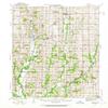
- USGS topographic map of Clarksdale, MO, at 1:62500 scale. Heavier material. Waterproof. Tear-resistant. Foldable. Perfect for the outdoors.
- Cities, towns, villages: Union Star,San Antonio,Bayfield (historical),Stockbridge (historical),Boxford (historical),Fountainbleau,Clarksdale,Clair,Rochester,Helena,Hurlingen,Cosby,Orchid,Oak
- Islands: Consult topo map preview for visible islands.
- Parks and forests: National Parks, National Forests, etc. Please preview map image for specifics.
Printed on Polypropylene
Shipping and Returns
- We offer tracked shipping on all orders. Tracking information will be shared as soon as the order is dispatched.
- Please check the delivery estimate before adding a product to the cart. This is displayed for every product on the website.
- Available shipping methods and charges will be displayed at the time of checkout, depending on your exact location.
- All customers are entitled to a return window of 14 days, starting from the date of delivery of the product(s).
- Customers are advised to read our return policy for details of the return process, eligibility, refunds as well as cancellations or exchanges.
- In case of any issues or concerns about Shipping or Returns, please contact us and we will be happy to help.
YellowMaps.
YellowMaps Clarksdale MO topo map, 1:62500 Scale, 15 X 15...
964,16 kr.
1,606,93 kr.
Save 40.0% (642,77 kr.)