
YELLOWMAPS
YellowMaps Chama NM topo map, 1:24000 Scale, 7.5 X 7.5 Minute, Historical, 1983, Updated 1983, 26.9 x 22 in - Polypropylene
964,16 kr.
1,606,93 kr.
Save 40% (642,77 kr.)
-
 Order within 21 hours and 54 minutes to get between May 14 - May 20
 -
 Tracked Shipping on All Orders
-
 14-Day Returns
- Secure Payments
-
 24/7 Customer Support
Description
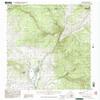
USGS topographic map of Chama, New Mexico, dated 1983, updated 1983.Includes geographic coordinates (latitude and longitude), lines of elevation, bodies of water, roads, and more. This topo quad is suitable for recreational, outdoor uses, office applications, or wall map framing.
Printed on-demand by YellowMaps on the print material of your choice.
Shipping rolled from Minneapolis, MN, United States.
Product Number: USGS-5379046
Map Size: 26.9 inches high x 22 inches wide
Map Scale: 1:24000
Map Type: POD USGS Topographic Map
Map Series: HTMC
Map Version: Historical
Cell ID: 8090
Scan ID: 192490
Imprint Year: 1983
Woodland Tint: Yes
Aerial Photo Year: 1976
Edit Year: 1983
Field Check Year: 1978
Datum: NAD27
Map Projection: Transverse Mercator
Provisional map: Yes
Map published by United States Geological Survey
Map Language: English
Scanner Resolution: 600 dpi
Map Cell Name: Chama
Grid size: 7.5 X 7.5 Minute
Date on map: 1983
Geographical region: New Mexico, United States
Northern map edge Latitude: 37
Southern map edge Latitude: 36.875
Western map edge Longitude: -106.625
Eastern map edge Longitude: -106.5
Surrounding map sheets (copy & paste the Product No. in the search bar):
North: USGS-5346407,USGS-5346403,USGS-5346405
East: USGS-5384975,USGS-5384973,USGS-5384971
South: USGS-5378484,USGS-5378486
West: USGS-5379102,USGS-5379104
Shipping and Returns
- We offer tracked shipping on all orders. Tracking information will be shared as soon as the order is dispatched.
- Please check the delivery estimate before adding a product to the cart. This is displayed for every product on the website.
- Available shipping methods and charges will be displayed at the time of checkout, depending on your exact location.
- All customers are entitled to a return window of 14 days, starting from the date of delivery of the product(s).
- Customers are advised to read our return policy for details of the return process, eligibility, refunds as well as cancellations or exchanges.
- In case of any issues or concerns about Shipping or Returns, please contact us and we will be happy to help.
YellowMaps.
YellowMaps Chama NM topo map, 1:24000 Scale, 7.5 X 7.5 Mi...
964,16 kr.
1,606,93 kr.
Save 40.0% (642,77 kr.)