
YELLOWMAPS
YellowMaps Alto TN topo map, 1:24000 Scale, 7.5 X 7.5 Minute, Historical, 1947, Updated 1948, 27.5 x 22 in - Tyvek
1,235,53 kr.
2,059,21 kr.
Save 40% (823,68 kr.)
-
 Order within 1 hour and 57 minutes to get between May 13 - May 19
 -
 Tracked Shipping on All Orders
-
 14-Day Returns
- Secure Payments
-
 24/7 Customer Support
Description
- Printed on Tyvek® (synthetic)
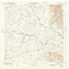
- USGS topographic map of Alto, TN, at 1:24000 scale. Lighter material. Waterproof. Tear-resistant. Foldable. Very durable. Perfect for backpacking and the outdoors.
- Cities, towns, villages: Glen,Oak Grove,Shady Grove,Wilder Chapel,Alto,Bells Mill,Prairie Plains,Pelham,Providence,Betsy Willis,Ruthledge Hill
- Mountains: Pull Tight Hill
- Valleys: Roark Cove,Bell Cove,Bost Cove,Pelham Valley,Tyree Cove
Printed on Tyvek
Shipping and Returns
- We offer tracked shipping on all orders. Tracking information will be shared as soon as the order is dispatched.
- Please check the delivery estimate before adding a product to the cart. This is displayed for every product on the website.
- Available shipping methods and charges will be displayed at the time of checkout, depending on your exact location.
- All customers are entitled to a return window of 14 days, starting from the date of delivery of the product(s).
- Customers are advised to read our return policy for details of the return process, eligibility, refunds as well as cancellations or exchanges.
- In case of any issues or concerns about Shipping or Returns, please contact us and we will be happy to help.
YellowMaps.
YellowMaps Alto TN topo map, 1:24000 Scale, 7.5 X 7.5 Min...
1,235,53 kr.
2,059,21 kr.
Save 40.0% (823,68 kr.)