
YELLOWMAPS
Pella IA topo map, 1:24000 Scale, 7.5 X 7.5 Minute, Historical, 1980, Updated 1980, 26.8 x 22 in - Polypropylene
964,16 kr.
1,606,93 kr.
Save 40% (642,77 kr.)
-
 Order within 38 minutes to get between May 13 - May 19
 -
 Tracked Shipping on All Orders
-
 14-Day Returns
- Secure Payments
-
 24/7 Customer Support
Description
- Printed on Polypropylene (plastic)
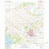
- USGS topographic map of Pella, IA, at 1:24000 scale. Heavier material. Waterproof. Tear-resistant. Foldable. Perfect for the outdoors.
- Cities, towns, villages: Pella,Howell (historical)
- Islands: Consult topo map preview for visible islands.
- Parks and forests: Rotary Park,Wallashuck Park,Lions Park,A N Kuyper Stadium,South Park,Caldwell Park,Brinkhoff Park,Brook Circle Park,Volksweg Trailhead Park,Historic Pella State Historical Marker,Big Rock City Park,Jaycee Park,Kiwanis Park,Central Park,Sunken Gardens Park,West Market Park,North Overlook Park
Shipping and Returns
- We offer tracked shipping on all orders. Tracking information will be shared as soon as the order is dispatched.
- Please check the delivery estimate before adding a product to the cart. This is displayed for every product on the website.
- Available shipping methods and charges will be displayed at the time of checkout, depending on your exact location.
- All customers are entitled to a return window of 14 days, starting from the date of delivery of the product(s).
- Customers are advised to read our return policy for details of the return process, eligibility, refunds as well as cancellations or exchanges.
- In case of any issues or concerns about Shipping or Returns, please contact us and we will be happy to help.
YellowMaps.
Pella IA topo map, 1:24000 Scale, 7.5 X 7.5 Minute, Histo...
964,16 kr.
1,606,93 kr.
Save 40.0% (642,77 kr.)